News
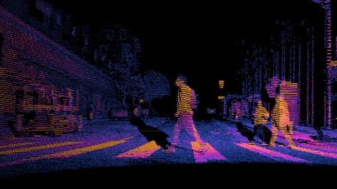
Innovative solutions have been added to the most diverse segments, including the adoption of sensors for image capture. Devices like LIDAR are used to solve problems in sectors such as the electrical sector, identifying both the shape and the real distance between objects. Image: Use of sensors in image capture: meet LIDAR
With the help of Computer Vision, the image capture process has undergone invaluable advances. Different devices can act in the process, varying according to the needs of the market segment and the type of operation that needs to be performed. Among them are sensors, instruments capable of bringing solutions to challenges faced in the most diverse industries. Still don't know what Computer Vision is and how it is applied? Understand here. According to Gartner, the use of sensors is among the top ten trends in the Internet of Things (IoT) through 2023, enabling the expansion of its use to an increasing number of solutions. Different types of sensors can be found on the market, capable of performing tasks such as generating data on equipment health or measuring temperatures. Today we will talk about the use of devices in image capture, a task considered fundamental in certain areas. Generally speaking, cameras can be considered sensors, since they are capable of capturing information from the environment in which they are inserted. However, a distinction must be made between so-called passive sensors and active sensors, as the possibilities for each use may vary.
Speak with one of our specialists and discover how Pix Force can transform your business
Different types of sensors
By responding to external stimuli, passive sensors work with information that already exists in the environment, collecting energy emitted or reflected by surfaces. Active sensors, on the other hand, emit signals to the environment with the goal of obtaining surface data as a response, generating information that can be used for different purposes. Most cameras can be treated as passive sensors, as they receive information from the environment to form images. However, it is possible to use cameras alongside other types of sensors, forming a kit of devices that will act in the same case, bringing flexibility and maximum efficiency in capturing information in certain environments. Among the most versatile and efficient types of active sensors is LiDAR, a device capable of identifying both the shape and the real distance between objects. Originally designed for military use, LiDAR-type sensors have been used in various segments and industries, with increasingly compact and lightweight versions that can even be mounted on drones.
LIDAR Sensors: solutions for different segments
Basically, the LIDAR sensor (acronym for light detection and ranging) can be understood as a remote sensing system capable of measuring distances between objects. Based on the emission of light signals that will be bounced off surfaces, the device is capable of reconstructing a three-dimensional space with the formation of a point cloud, also called point clouds. The information will be interpreted reliably by the system, representing the target being captured. There are numerous advantages brought by using the LIDAR-type sensor, especially the model used by Pix Force, the OS1 produced by the leader in technological solutions Ouster. The first of these is the possibility of use in different lighting levels, including in the complete absence of light. In addition, LIDAR can be implemented on fixed or mobile points, such as cars, drones or planes that travel long distances scanning the terrain. Image: Use of sensors in image capture: meet LIDAR
The use of technology can boost map generation in different segments, such as mining, agriculture and forestry, promoting rapid and accurate mapping. The LIDAR sensor gains even more versatility when used in conjunction with other devices, working in an integrated manner. This is the case in the electricity sector, which faces wasted financial resources due to power outages caused by contact between wires and trees. To solve the problem, Pix Grid, a vertical of Pix Force, is developing a solution for CPFL Energia that combines the LIDAR system with other technologies. The goal is to map vegetation that needs pruning before accidents on the grid occur.
Use of sensors in the electricity sector
In the electricity sector, the presence of trees close to power distribution grids on streets causes losses. After all, poor pruning management ends up being responsible for supply interruptions in the grids, generating financial costs and also reducing the quality of the service offered to the population. To give you an idea, data from the National Electric Energy Agency (ANEEL) point to a cost of R$ 8 billion in 2020, thanks to technical losses that include supply interruption due to short circuits. The high number of supply drops and consequent emergency services generate losses for the sector, making it necessary to introduce Artificial Intelligence (AI) solutions capable of solving the problem. Image: Use of sensors in image capture: meet LIDAR
Based on scanning the distribution network, the solution developed by Pix Grid uses Computer Vision to prioritize pruning work, acting to reduce maintenance costs. A car equipped with different types of devices, including cameras and a LIDAR sensor, ensures the accuracy of positioning data, presents three color dimensions, in addition to a high-precision geolocation system. Activities involving tree pruning account for about 30% of operational costs. With the help of the solution, it is possible to scan the distribution network, measuring distances and identifying locations where vegetation is close to the wires. From the data generated, it is possible to define which pruning should be carried out with a higher level of priority, preventing accidents. Lucas Ramalho, Image Processing Analyst at Pix Force, explains how the integration between each type of sensor is capable of generating such valuable data. “We need the notion of depth to guarantee the mapping of power distribution networks. If the images were captured with a cell phone, for example, we will be able to see that there are wires passing in front of the trees, but it will not be possible to measure the real distance between the objects. With the help of LIDAR, we can obtain the exact position, based on reality and without distortion,” he explains. Learn more about Pix Grid solutions here .
Advances in image capture
In addition to the uses already mentioned, the LiDAR sensor can be used in monitoring highway slopes. Positioned in a fixed manner, the sensor helps in issuing alerts if landslides occur outside of levels considered acceptable, preventing accidents. Other possibilities include the development of autonomous cars, allowing automobiles to move without colliding with other objects. The capture and processing of images through Computer Vision have become increasingly accessible and cheap, bringing growth opportunities for the national industry. If they want to increase their competitiveness, managers need to pay attention to innovative processes emerging in the market, including the use of sensors promoted by startups active in the development of disruptive technologies. Learn about the multiple uses of the LiDAR sensor here .

Fabio Caraça
Fábio Caraça is the Chief Growth Officer at Pix Force. He leads Pix Force's transformation into a scalable SaaS operation, combining strategic vision, culture, and high-impact execution.