News
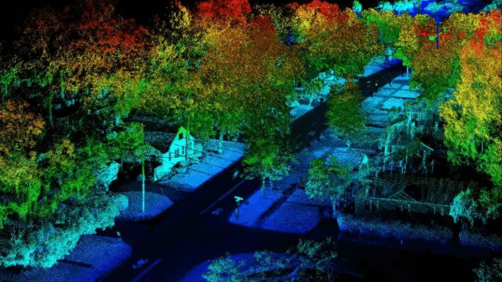
How can the LiDAR sensor transform the way humans make measurements? Standing for "light detection and ranging", LiDAR is a 3D sensor that measures the distance between objects using a laser that hits the target object and analyzes the reflected light. Through this system, scientists and professionals can investigate natural and man-made environments with precision and flexibility. LiDAR consists of a remote sensing system that sends beams of infrared light to a specific target. From this, it interprets the light signals bounced back by nearby objects, forming a pixelated image called a point cloud. The goal is to accurately represent the surface of an object, but the level of precision can vary from sensor to sensor, depending on the power, configuration, and resolution of each unit. READ ALSO: • Computer Vision: A Complete Guide to clear your doubts
• Intelligent Technology in the mining sector
• What is LiDAR?
Speak with one of our specialists and discover how Pix Force can transform your business
How does this 3D sensor work?
High-speed light signals are fired at a nearby surface – about 150,000 pulses per second. The sensor measures how long it takes for these light signals to bounce back, making it possible to measure the distance between objects. This calculation allows the 3D sensor to precisely read the distance between the emitter and the target. From this sequence of tasks, executed repeatedly and very quickly, the unit creates a detailed image of the nearby environment. A camera-based vision system relies on two-dimensional images to be processed and interpreted, whereas LiDAR sensors speed things up by making millions of measurements in real time and in all directions. In view of this, the main limitation of the LiDAR sensor is still the inability to see beyond solid objects, and the measurement will suffer interference if the sensor's light beam is blocked by some other solid thing, adverse weather conditions, and signals from other sensors. Despite this, overcoming these limitations is possible and is a constant challenge for LiDAR developers.
How and where can the LiDAR sensor be revolutionary?
There are infinite application examples for LiDAR's powerful sensors, it being one of the many fruits of the 4th Industrial Revolution. Basically, the LiDAR sensor can impact and benefit any area of human interest, from the most basic and everyday to the most complex, bureaucratic, and even controversial, such as the polemical topic of facial recognition. The 3D sensor can be used to: • map planets and natural satellites;
• be used to improve meteorological sciences and generate more accurate and faster weather forecasts;
• remotely monitor preservation areas such as natural sanctuaries and risk areas, and track changes in glaciers and the ocean;
• help in anticipating the occurrence of natural disasters such as tsunamis and landslides;
• be applied in numerous operations to monitor and inspect land and structures, from microparticles invisible to the naked eye to gigantic buildings;
• can (and should!) be widely used in medical sciences, such as tissue and tumor analyses.
However, there are some specific areas where the use of LiDAR can be truly revolutionary and definitively transform how humans perform certain tasks, eliminating risks and errors or simply facilitating and accelerating the execution of those tasks. These are essential areas for the future and for society, guaranteeing the LiDAR sensor a prominent position in the main technological innovations for Industry 4.0. Check it out below.
AGRICULTURE
Harvest viability
The exponential growth of the world's population has brought back to the forefront a discussion about feeding methods and generated a certain pressure on agricultural production, in addition to the demand for food waste reduction and reliable statistics on harvests and yields worldwide. For better results in the harvest and yield, each stage of planting needs to be accompanied by a report with exact and transparent data. The 3D sensor can solve this problem and serve as a territorial management tool. Sensing can be applied in topographic and soil property analyses to, from there, allow producers to create better planting models in any area of the field. Planting areas are mapped and classified based on the needs of each species: more moisture, less lighting, etc. This solution saves the use of fertilizers and, as a bonus, contributes to improving soil and food quality.
Investigating Landslides and Slope Stability
For landslides, LiDAR scans obtain a better representation of the surface in vegetated areas. From shaded relief, slope, and topographic contours, it is possible to identify morphological features common to landslides. It is in these densely vegetated and mountainous areas that surveyors create landslide inventories. Overall, it can predict landslide events and better assess safety risks.
AUTONOMOUS VEHICLES
Navigation
It is no surprise to anyone following advancements in autonomous vehicle technology that LiDAR is increasingly becoming popular as a guidance system to make these types of vehicles viable in a much closer future than we imagine, thanks to its fast and accurate system that allows the vehicle's processor to see obstacles and update its trajectory in seconds. From the exact position of surrounding obstacles, the 3D sensor guides the vehicle in the right direction and avoids collisions. In the event of imminent contact, the system recalculates the route to minimize damage as much as possible.
Green Energy and LiDAR Sensor
Wind Turbines
Each gust of wind is scanned before hitting the blades. Efficiency is maximized by calculating the wind's direction and intensity and, if necessary, the blade direction changes to generate more power.
Wind Speed Measurement
An accurate wind speed measurement system is crucial for the efficient installation of wind farms. LiDAR can measure wind speed at higher altitudes, further away, and faster than traditional meteorological masts. The 3D sensor can be installed on top of one of the turbines to measure wind conditions daily from all directions.
Solar Energy Planning
The use of solar energy is increasingly popular and LiDAR helps identify some basic requirements for installing solar panels, such as minimum required areas and roof position relative to the cardinal points.
Mining
Quarries and Minerals
The sensor can also be used for extracting rocks and minerals and for detecting pollutants. It can also be used to perform topographic assessments and geoprocessing of environments, checking the environmental effects of each project.
Ore Volume Calculation
In mining, risks are high due to the use of heavy machinery and hard-to-access terrains. Thanks to its ability to collect data on ore directly from the source, LiDAR eliminates the need for human presence, reducing risks. Scanning of the areas is typically done with drones.
LiDAR Sensor in the Forestry Industry
Forest Management
This system can accurately measure both the forest canopy structure (treetops) and the ground below. This solution is much more cost-effective and allows for large-scale assessments. In areas spanning many kilometers, this task is extremely difficult and costly.
Precision Forestry
Forestry is the science dedicated to studying natural and artificial methods to regenerate and improve forest conditions. Its goal is to provide a more rational use of forest stands. That said, precision forestry develops the smart use of forest systems based on decisions made from accurate data. LiDAR provides a detailed reading of forest dynamics, enabling organizations to gather meaningful and more relevant data.
Deforestation
One of the biggest environmental problems today is deforestation, an event that is not new, but has been taking on greater proportions each year. LiDAR technology can help significantly in this area by identifying forest areas affected by human action. It can be used to three-dimensionally measure the structure of the tree canopy, including its height and diversity, such as leaves and branches. The data can even impact protection projects for the Amazon, the largest tropical rainforest on the planet, completely transforming forestry solutions.
Fire Management
Throughout the world, firefighters are discovering the potential of LiDAR sensor technology to prevent and monitor forest fires. Patterns in fire occurrence can be observed and areas can be classified by risk level. In this way, efficient prevention and maintenance measures can be taken faster.
LiDAR Sensor in Augmented Reality Implementation
As LiDAR becomes more ubiquitous in smartphones, its integration into video games is becoming a reality. Augmented reality, that is – pun intended. It is Augmented Reality that allows interaction with the outside world using your smartphone screen. LiDAR adds a depth sensor to make this possible. But this does not apply only to gaming: it also serves for placing transmission towers, wind turbines, and solar panels.
Mobile LiDAR and Cities
Cities are leveraging mobile LiDAR for asset management and ensuring safety standards. For example, available data on public services includes everything from potholes, road conditions, bridge damage, utilities, company-placed billboards, and street signs. After data collection, scans are directed to their respective geospatial databases. This way, they can store, analyze, and visualize each infrastructure asset – which is the main function of a Geographic Information System (GIS). A construction scan with LiDAR makes it possible to ensure construction matches with Building Information Modeling (BIM). Aligning the point cloud of a terrestrial scan with a BIM project guarantees construction quality, deadline compliance, and better operational efficiency for the labor force. The biggest advantage is that performing real-time scans can detect potential defects early in the project. Otherwise, time and money would be wasted to redo any faulty construction. Pix Force's business solutions package includes all the hardware and software needed to generate fast, accurate, and cost-effective 3D point clouds, maps, and models. Want to discuss the possibilities of aerial drone LiDAR for your business? Our friendly professionals are eager to help you! To learn even more about the future of remote sensing and the potential of LiDAR, click here!

Fabio Caraça
Fábio Caraça is the Chief Growth Officer at Pix Force. He leads Pix Force's transformation into a scalable SaaS operation, combining strategic vision, culture, and high-impact execution.