News
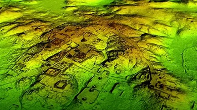
How to measure 3D obstacles in real-time? Is the development of fully safe autonomous cars possible? Can we measure distances in situations where light is absent? All these are questions that lead us to the same answer: LIDAR (Light Detection and Ranging). But what is LIDAR? LIDAR is a technology that features an active optical sensor, which emits light beams in the infrared region of the electromagnetic spectrum, with wavelength variations between 0.7 µm and 1000 µm, and determines the distance by calculating the reflection time of the laser pulses to the objects around it. LIDAR sensors are used in many industry sectors, including: • automotive
• infrastructure
• robotics
• trucks
• drones
Since LIDAR is its own light source, the technology offers strong performance in a wide variety of weather and lighting conditions. Want to know more about LIDAR? Come with us! READ ALSO: • What is machine learning?
• Uses of remote sensing
• Learn more about the applications of technologies in the industry
Speak with one of our specialists and discover how Pix Force can transform your business
How is LIDAR used?
Currently, this technology is employed in various sectors of the economy. In the forestry field, it can be used to obtain greater detail of the stands of interest, resulting in more assertive data on planting development and volume quantification compared to traditional inventory methods. It also has the advantage of not requiring ambient light, thus terrain and surface models are obtained without having to worry about weather conditions, providing greater agility in the process. As a technology that produces a large amount of spatial data with millimeter resolution, it has become the main tool for autonomous vehicle developers. However, going against this usage is Elon Musk, CEO of Tesla, who believes that LIDAR sensors are dispensable for solving the problem in autonomous cars. According to Musk, there is a truly high cost associated with each sensor, and he claims that using only computer vision involving other sensors such as cameras and radars will be sufficient to develop the product expected by the market. Therefore, LIDAR is a technology that is here to stay. Previously available only for industrial and scientific applications, these sensors will be increasingly present in our lives, from our cell phones to our cars, homes, and hospitals. Contrary to what Elon Musk says, LIDAR is a complementary sensor to conventional cameras, and we will likely see more and more integration between the two systems, as they are so complementary. LIDAR, for example, works even in the complete absence of light. On the other hand, although they depend on an external light source, traditional cameras capture a critical data point absent in LIDAR: colors. There is no doubt that both technologies are complementary and will walk hand in hand, helping to reduce our transportation risks and improving our quality of life.
LIDAR in the autonomous car industry
Overall, LIDAR sensors are being widely used in autonomous vehicles since they provide a high-resolution 3D view of their surroundings. We can say in a very simplified way that LIDAR works like the eyes of autonomous vehicles. In other words, through these sensors, vehicles are able to measure millions of data points in real time, creating an accurate map of their constantly changing surroundings for safe navigation. LIDAR's distance accuracy is highly efficient, helping vehicles avoid objects up to 300 meters away in a wide variety of weather and lighting conditions.
LiDAR in SURVEYING
LiDAR sensors can be attached to drones to generate 3D digital terrain models (DTM) quickly, accurately, and cost-effectively from remote or irregular areas. UAVs are the right tools to cover specific land areas in situations where a manned aircraft is a costly overkill. Drones are easier and faster to deploy than airplanes or helicopters, thereby reducing costs and risks.
POWER LINE INSPECTION FOR MAINTENANCE
Regular maintenance of power lines presents major safety risks. LiDAR technology is capable of identifying problems in power lines before they become an even greater controversy. Through the use of UAVs, utility companies can quickly assess damage to devise a solution with the lowest possible level of risk.
SILVICULTURE AND AGRICULTURE
Drones equipped with LiDAR can be deployed to conduct surveys on large farms, helping to determine how resources can be used to increase productivity. They can also be used in forestry areas to create 3D models that show the impact of human activity on a given rural or forest area. One of the main advantages of LiDAR is that it is able to penetrate the view beneath the tree canopy, giving a view of the ground.
APPLICATIONS OF LiDAR IN MINING AND TRANSPORTATION
LiDAR proves to be an excellent tool for calculating material volumes in open-pit mines without disrupting work on the ground. Integrating drones into mining workflows reduces time, costs, and risk exposure. Urban planners looking for a powerful tool to help expand public transit systems and railway stations need look no further than LiDAR technology. UAVs with LiDAR sensors are capable of scanning wide areas and generating useful data to help determine plans for future transportation infrastructure. So, what did you think of our definition of LiDAR? Want to know all about technology and how to implement technological solutions for your company? Contact us!

Fabio Caraça
Fábio Caraça is the Chief Growth Officer at Pix Force. He leads Pix Force's transformation into a scalable SaaS operation, combining strategic vision, culture, and high-impact execution.