News
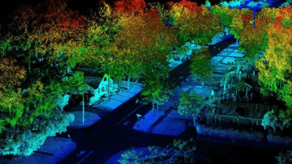
How can the LiDAR sensor transform the way humans make measurements? Standing for "light detection and ranging", LiDAR is a 3D sensor that measures the distance between objects using a laser that hits the target object and analyzes the reflected light. Through this system, scientists and professionals can investigate natural and man-made environments with precision and flexibility. LiDAR consists of a remote sensing system that sends beams of infrared light to a specific target. From this, it interprets the light signals bounced back by nearby objects, forming a pixelated image called a point cloud. The goal is to accurately represent the surface of an object, but the level of precision can vary from sensor to sensor, depending on the power, configuration, and resolution of each unit. READ ALSO: • Computer Vision: A Complete Guide to clear your doubts
• Intelligent Technology in the mining sector
• What is LiDAR?
How does this 3D sensor work?
High-speed light signals are fired at a nearby surface – about 150,000 pulses per second. The sensor measures how long it takes for these light signals to bounce back, making it possible to measure the distance between objects. This calculation allows the 3D sensor to precisely read the distance between the emitter and the target. From this sequence of tasks, executed repeatedly and very quickly, the unit creates a detailed image of the nearby environment. A camera-based vision system relies on two-dimensional images to be processed and interpreted, whereas LiDAR sensors speed things up by making millions of measurements in real time and in all directions. In view of this, the main limitation of the LiDAR sensor is still the inability to see beyond solid objects, and the measurement will suffer interference if the sensor's light beam is blocked by some other solid thing, adverse weather conditions, and signals from other sensors. Despite this, overcoming these limitations is possible and is a constant challenge for LiDAR developers.
How and where can the LiDAR sensor be revolutionary?
There are infinite application examples for LiDAR's powerful sensors, it being one of the many fruits of the 4th Industrial Revolution. Basically, the LiDAR sensor can impact and benefit any area of human interest, from the most basic and everyday to the most complex, bureaucratic, and even controversial, such as the polemical topic of facial recognition. The 3D sensor can be used to: • map planets and natural satellites;
• be used to improve meteorological sciences and generate more accurate and faster weather forecasts;
• remotely monitor preservation areas such as natural sanctuaries and risk areas, and track changes in glaciers and the ocean;
• help in anticipating the occurrence of natural disasters such as tsunamis and landslides;
• be applied in numerous operations to monitor and inspect land and structures, from microparticles invisible to the naked eye to gigantic buildings;
• can (and should!) be widely used in medical sciences, such as tissue and tumor analyses.
However, there are some specific areas where the use of LiDAR can be truly revolutionary and definitively transform how humans perform certain tasks, eliminating risks and errors or simply facilitating and accelerating the execution of those tasks. These are essential areas for the future and for society, guaranteeing the LiDAR sensor a prominent position in the main technological innovations for Industry 4.0. Check it out below.
Speak with one of our specialists and discover how Pix Force can transform your business
AGRICULTURE
Harvest viability
The exponential growth of the world's population has brought back to the forefront a discussion about feeding methods and generated a certain pressure on agricultural production, in addition to the demand for food waste reduction and reliable statistics on harvests and yields worldwide. For better results in the harvest and yield, each stage of planting needs to be accompanied by a report with exact and transparent data. The 3D sensor can solve this problem and serve as a territorial management tool. Sensing can be applied in topographic and soil property analyses to, from there, allow producers to create better planting models in any area of the field. Planting areas are mapped and classified based on the needs of each species: more moisture, less lighting, etc. This solution saves the use of fertilizers and, as a bonus, contributes to improving soil and food quality.
Investigating Landslides and Slope Stability
For landslides, LiDAR scans obtain a better representation of the surface in vegetated areas. From shaded relief, slope, and topographic contours, it is possible to identify morphological features common to landslides. It is in these densely vegetated and mountainous areas that surveyors create landslide inventories. Overall, it can predict landslide events and better assess safety risks.
AUTONOMOUS VEHICLES

Fabio Caraça
Fábio Caraça is the Chief Growth Officer at Pix Force. He leads Pix Force's transformation into a scalable SaaS operation, combining strategic vision, culture, and high-impact execution.